 Abstract
 Abstract
Cape Rodoni (Albania) splits Lalzit bay in two parts. Patok-Rodoni bay is impacted by continuous flow-outs of Ishmi and Mati rivers, despite of its relevant biodiversity and the presence of fragile wetlands, complaints a sedimentation effect on the residual Posidonia meadows and a geophysical disturbance due to various inland activities, contaminants and marine-litter.
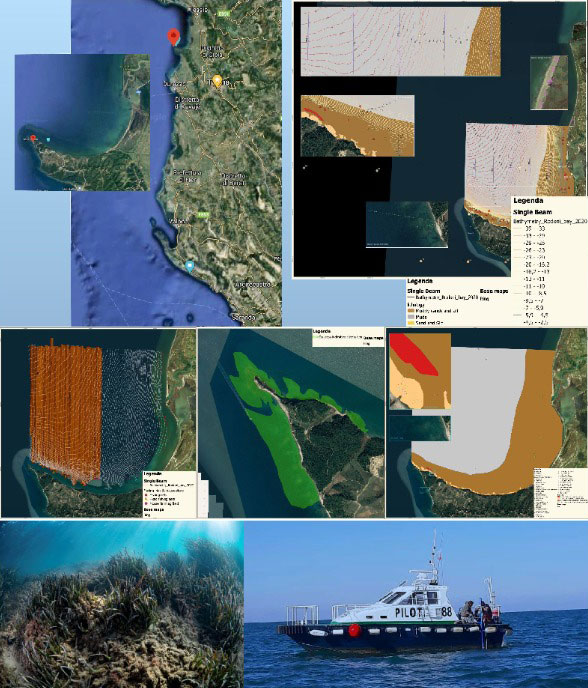
During 2020 a first IMAP marine survey was conducted by an Albanian-Italian team within the GEF Adriatic Project. During field phase, IMAP Ecological Objectives (EO) were investigated and environmental data were collected to comply all relevant Common Indicators (CI) requested. 8 sampling stations, distributed along 3 transects, have been monitored, in order to assess the GES of the area and identify the main threats.
Modern oceanographic equipment were used.
Scientific Divers and video-reporters were involved to realize both bionomic underwater LIT transects, both photo-video documentation and innovative 360 VR tour, as a new tool for scientific dissemination. Data has been entered into IMAP InfoSystem and presented in GIS-based maps. This IMAP survey provided relevant scientific informations about CI: EO1, EO2, EO5, EO7, EO9, EO10 and provided preliminary data for Fisheries in Albania.
Key-words: IMAP marine survey, Ecological Objective (EO), Common Indicator (CI), SSS-
SBES, Scientific Divers
Introduction
GEF Adriatic project aims to support MSP throughout the Adriatic region as a tool for sustainable development. It’s among the first initiative of its kind, embedding national IMAPs developed within the Barcelona Convention (BC) into MSP to achieve GES of the Mediterranean Sea (Bianchi & Morri, 2000). This project has implemented in Albania by UNEP/MAP, PAP/RAC, SPA/RAC with NAPA and Albanian Ministry of Tourism and Environment.
The surveyed area of Patok-Rodoni Bay is known for its relevant biodiversity and protected areas, but it’s impacted by human activities and appears strongly influenced by water exchanges with Patok Lagoon, Ishmi and Mati rivers. This study focused in particular on CIs of IMAP EOs related to: biodiversity, hydrology, eutrophication, contaminants and marine litter.
Materials and methods
All sampling activities performed were aligned with IMAP (UNEP/MAP, 2016) methodology as agreed by the Contracting Parties to the BC. During field phase, IMAP EOs (EO1, EO2, EO5, EO7, EO9, EO10) were investigated and environmental data were collected to comply with all relevant CIs requested. 8 sampling stations, distributed along 3 transects (off-shore, Patok bay, Lalzit bay) have been monitored, in order to assess the GES of the area and identify the main threats (Deudero & Alomar, 2015). Modern oceanographic equipment were used. Scientific divers and videoreporters realized both bionomic underwater LIT transects, both photo-video documentation and innovative 360 Interactive Virtual Tour, as new media tool for scientific dissemination process.
Results
Final results have been presented into many products: 1 Final Report, 20 Annex Files, 1
Executive Summary, 1 On the Job Training, 1 complete GIS based maps, 1 Monitoring Database on IMAP Info System, 1 UHD photo reportage, 5 4k videos from ROV and dives, 5 mins short promo clip, 25 mins video-documentary and 1 Interactive Virtual Tour.
A complete echo-mosaic from SSS-SBES, ROV and Scientific Dives surveys of the whole Patok-Rodoni Bay has been produced. Thanks to these new bionomic maps some interesting coralligenous assemblages have been identified both in the center of the bay, both along the deepest bathymetrics over the cape towards off-shore Sea.
Discussion
Results and recommendations will be useful to assess the levels of pressure on the environment and identify the most fragile areas of Patok-Rodoni Bay, to finally affine the Albanian Integrated Monitoring Programme within the area and propose measures allowing the preservation of marine areas and the development of sustainable economic activities.
Results complaint a sedimentation effect on the rare Posidonia meadows (Buia et al., 2003) and a geophysical impact due to various inland anthropogenic activities, contaminants and marine-litter.
Final recommendations represent ideas both for planning, both for future management and interventions that, in long term, could guarantee an improvement of the present habitats and marine life: this must be the “first food for thought” aiming at the development or control of socio-economic activities (tourism, fishing, water sports) and environmental protection (marine and coastal protected areas) in Patok Rodoni Bay area, as currently considered by National Authorities.
Acknowledgments
Special thanks goes to: SPA/RAC; NAPA; Albanian Diving Federation; Albanian Shengjin Port authorities and community of Patok-Rodoni bay who supported project activities.